

Authors: Samad Ahmed, Tina Chen, Sheela Pandit
Introduction
Are you struggling to get to class on time? Annoyed by having to load up multiple transportation apps simultaneously? Don’t have a car or want to spend a steep price on Uber? Spending too long deciding whether to walk or take the bus? Many students are not able to afford unnecessarily long, complicated, and expensive commutes, but the best transportation option may not be obvious.
Our detailed, seven-step guide explains how to easily identify the best way to plan out routes. We focus on important locations, including around campus, MARTA stops, and grocery stores. We then provide detailed information regarding different transportation options, such as walking, using the bus, scootering, and taking MARTA. We also account for the different factors that can influence the user’s transportation choice, including time limits, route conditions, cost, and weather. After reading our guide, users should be able to successfully navigate campus with efficiency and ease.
Step 1: Identify your destination
Before you leave your starting spot, it is important to know exactly where you are going. You can mark down your target location(s) in Google or Apple Maps to get a good preview of your route. See below for a comprehensive map of the Georgia Tech Campus.
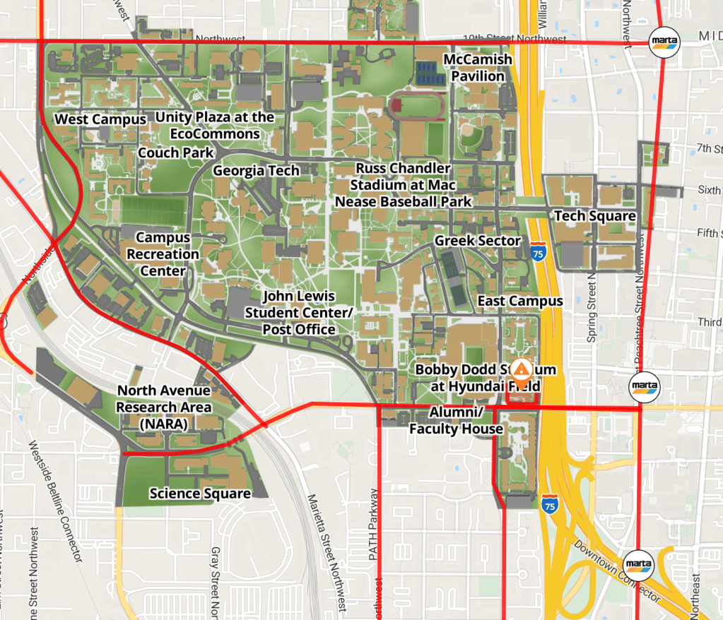
Map of Georgia Tech Campus
The locations below are commonly frequented by students, and you can use our method to find the best way to get to each of them.
On-Campus
- Dining Halls
- Student Center
- Library
- Football Stadium
MARTA Stops
- Midtown
- North Avenue
- Civic Center
Grocery Stores
- Publix
- Lidl
- Trader Joe’s
- Kroger
- Target
Other Locations
- Mercedes Benz Stadium
- Piedmont Park
- Krog Street
- Georgia Aquarium
- World of Coke
Step 2: Time the walk
Walking is the most simple and often the most convenient form of transition, especially for short commutes. Walking speed differs greatly from person to person, so it is crucial to know how this factor will affect your travel time.
Time Estimate
Google and Apple Maps provide reasonably accurate walking times since they base their estimates on your walking speed data. These apps also usually provide the fastest route.
Step 3: Check out bus routes
The Stinger Buses and Stingerettes are useful free options when you don’t feel like walking or have something to carry.
Stinger Bus
The Stinger Bus system spans across campus and runs daily; however, schedules are different on weekends and holidays. You can find more information here.
Stingerette
The Stingerette system is an on-demand service that runs from 4:30 to midnight on all days excluding holidays and home football games. The Georgia Tech Police department is also available at night for requesting rides. You can find more information here.
Time Estimate
The Transloc App provides live information on when the buses and Stingerettes will arrive, not necessarily how long the commute will take. The time spent on the bus or shuttle will typically be less than the walking time.
Step 4: Assess scooter and bike paths
Students who possess scooters or bikes may also prefer these transportation options since they can be utilized both on and off campus. If you plan to do so, ensure that you have completed the required registration. Students who do not own personal scooters or bikes may rent through Lime.
Lime
Lime bikes and scooters will cost money to rent, which is an important consideration. Rates vary based on time spent using the bike and frequency of use. There are specific stop points on campus, outside buildings, where scooters and bikes can be locked up. You can find more information here.
Time Estimate
Scooters and bikes are faster than walking. They are also typically faster than riding a bus since there is no wait time, and you can travel to your exact location instead of being constrained to bus stops. However, it is important to ensure that you ride safely and follow traffic rules.
Step 5: Look into MARTA
MARTA is useful for off-campus travel within Atlanta. Each MARTA ride is $2.50, making it much more affordable than Uber. If you travel frequently on the MARTA, you can purchase a discounted student pass for $68.50 per month. Each train runs every run approximately every 10-12 minutes during peak weekday hours and every 15-20 minutes during off-peak and weekend hours. See below for an image of all MARTA train routes.

All MARTA routes and station stops.
Time Estimate
Google Maps provides an estimate of the time it takes to ride MARTA, accounting for wait times. When planning a trip via MARTA, ensure that you also account for the time it will take to walk from the station to your destination.
Step 6: Compare all options
Once you have all feasible options outlined, you can compare them. Make sure to add up the total walking, waiting, and transit time for accurate comparison. We provided a sample comparison chart for traveling from West Village Dining Hall to Bobby Dodd Stadium.
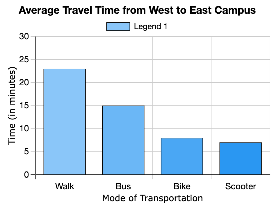
Time comparison chart for walking, riding the bus, biking, and scootering from West Village Dining Hall to Bobby Dodd Stadium
For this particular route, scootering would be the fastest transportation method.
Step 7: Account for Other Factors
You should always be prepared to change your plan in the case of emergencies. We highlighted some events which will affect transportation and how to prepare for them.
| Emergency | Recommendation |
| Severe weather (thunderstorm, snowstorm, etc.) | Avoid walking and riding scooters and bikes. Use options which provide cover, such as Stinger buses, Stingerettes, or MARTA. |
| Football game | Roads will be closed, and the bus service will not run. Riding a bike or scooter may not be feasible if there are large crowds. Walking is preferred but may take additional time. |
| Road closure | If roads are closed, so too are the bike lanes, leaving only walking as an option on campus. If the destination is significantly further, MARTA may work as well. |
Events which will effect your commute and recommendations for how to account for them.
Resources
For more information regarding the listed transportation options, see the links below.
Stinger Bus
- General information: https://www.pts.gatech.edu/shuttles/stinger/
Stingerette and Police
- Stingerette: https://www.pts.gatech.edu/shuttles/stingerette/
- Police: https://police.gatech.edu/
Bikes and Scooters
- Lime: https://www.li.me/locations/atlanta
- New bike/scooter registration: https://www.pts.gatech.edu/2026/07/28/new-bike-scooter-registration/?utm_source=newsletter&utm_medium=email&utm_content=New%20Process%20for%20Bike%2C%20Scooter%20Registration&utm_campaign=Daily%20Digest%20-%20Aug.%203%2C%202026
MARTA
- General information: https://itsmarta.com/
Parking and Transportation
- General information: https://www.pts.gatech.edu/


Leave a Reply